Hiking Trails
RED ROUTE
BETWEEN NATURE AND HISTORY
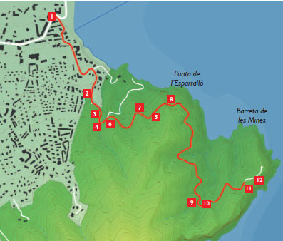
First trail 1: Albir lighthouse.
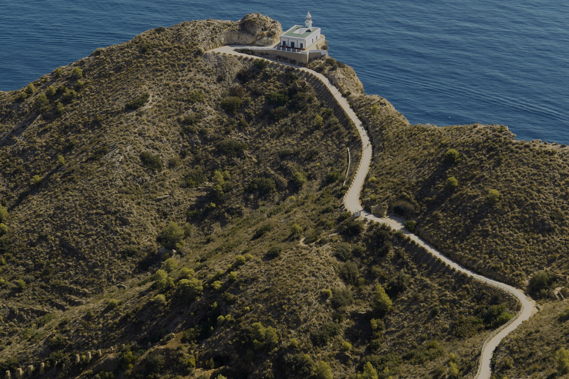
The path to Albir lighthouse offers the possibility to enjoy some of the most beautiful scenic views in this part of the Mediterranean. Suitable for all the family and totally accessible, it´s an easy path to follow, along an asphalted road that takes us to the lighthouse in Albir, just upon Punta Bombarda point.
The itinerary perfectly combines nature and history, with mines dating back to the Phoenicians and to the Romans, who would mine and extract ochre, along with a cistern that provided water to the lighthouse, or the ruins of the Bombarda defensive watchtower. Along the path you will find viewpoints, coves and 13 instructional panels where, aside from explaining the natural, cultural, historical and geological heritage, you will also discover details and legends about the area. At the end of the path, the presently restored lighthouse has become an interpretation centre, with an exhibition on life at the lighthouse and the rich biodiversity of the natural park.
Description:
Difficulty: Low
Distance: 5 kilometres (there and back)
Duration: 1 hour 30 mins to 2 hours
Maximum gradient: 60 metres
Accessibility: Asphalted trail.
Suitable for hiking, cycling and wheel chairs.
From the parking lot for the path to Albir lighthouse, considered the main entrance to the Natural Park, we have to follow the asphalted trail up to a tunnel on the path. Before getting there we can find a picnic area to our left and further on a circular viewpoint from which we can see a magnificent perspective of the whole bay, with the Peñon de Ifach rock and the rest of the spectacular mountains that surround this corner of the Marina Baixa region. When reaching the tunnel entrance we can access another viewpoint, smaller than the previous point, from where we can enjoy the impressive coastline that surrounds the Natural Park. We continue unto the lighthouse and, 300 metres later, we can find signs marking the access points to the Cala de la Mina cove and, further on, the access to the ochre mines, from where ochre was extracted and was used as a dye until well into the 20th century. Some 500 metres past the tunnel we get to a curve in the trail from where we can see, to our right and higher up, a large natural opening in the mountain´s shadow know as the “Boca de la Balena” or “Cova del Bou” cave. Just before you reach the lighthouse, to your right, you will find the viewpoint “Alfonso Yébenes” from where we can appreciate part of the cliffs and a few metres on and to the left you can find the reconstructed water deposit with its hydraulic structure (16th century).
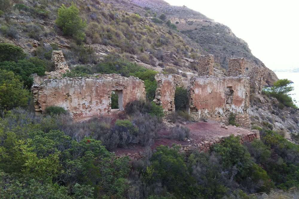
At the end of the trail you will find the remains of the Torre Bombarda watchtower, declared a site of cultural interest for being part of the Valencian coastal defence system between the 16th and 17th centuries, and the lighthouse, also known as Albir lighthouse interpretation centre. Around the still working lighthouse there is a spectacular viewpoint balcony from where we can enjoy a much wider perspective of our Mediterranean Sea.
DOWNLOAD THE LOCAL GUIDE FOR THE PATH TO THE LIGHTHOUSE
Guide Lighthouse Path in Spanish
Guide Lighthouse Path in English
Guide Lighthouse Path Simplified in Spanish
Yellow Route
ARE YOU BRAVE ENOUGH TO FOLLOW THIS CHALLENGING TRAIL?
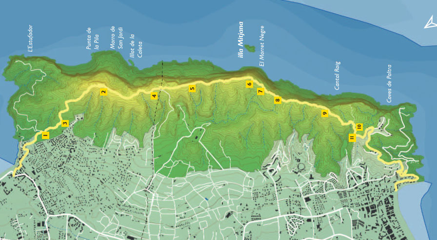
Itinerary 2: Across Serra Gelada
A hiking trail that will amaze you both for its beautiful views as well as for its demanding path. The combination of sea and mountain in a single outing is the main attraction of this trail. We can enjoy intimate moments while peering over the giddy cliffs that fall to the Mediterranean Sea.
Description:
Difficulty: Moderate-high.
Distance: 6,5 kms (one way)
Duration: from 3,5 to 4 hours.
Maximum gradient: 438 metres
Accessibility: only suitable for hiking
It can be done in both directions or only in one, there or back. Remember that it is a demanding trail due to continuous slopes up that rise and fall. The absence of drinking fountains along the trail force us to carry plenty of drinking water. At the official entrance to the Natural Park we can find the signs to the trail on our right. At the top of this trail, that passes close to La Cantera landscape interpretation centre, we can reach the highest point of Serra Gelada, the “Alt del Govenador” summit (438 metres), where we can find a telecommunications antennae. Following an asphalted trail that leads down we can link up with the trail once again. Towards the cliff edge we can find a geodesic vortex from where we can observe the majesty of this precipice, watching the seagulls fly hundred of metres below us, tiny specks along the horizon. The trail along the mountain range continues with constant rising and falling slopes, passing the ruins of an old house used as a coastal watch tower and a small water deposit in the crease. Halfway along the way we will find an area with a small group of pine trees where we can rest for a moment, offering us a beautiful view of the “Illa Mitjana” islet. The last stretch of the mountain passes a height we can see the cliffs once again. From this emplacement we have to be wary we don´t lose the trail that continues through low brush and naked rock. A few minutes later we will reach the cross monument rising over the “Racó de l`Oix” neighbourhood in Benidorm, where we can start to descend along an asphalted road that connects with Levante Beach. To return, we can find a bus stop at the end of Avenida Mediterráneo avenue where we can take the number 10 bus that takes us back to Albir (Benidorm, l´Alfàs del Pi, Albir Beach), getting off at the Roman Villa and Fundación Frax bus stop.
SERRA GELADA BICYCLE LANE
Do you like cycling?
The routes along Serra Gelada Natural Park are made of lanes without motor vehicles, dirt roads and shared roads with motor vehicles. They are suitable for hiking and cycling except for the yellow route (across Serra Gelada) that is only suitable for hiking. On the path to the lighthouse, bicycle and motor vehicle access is regulated and limited according to local laws.
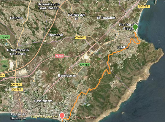
One trail stands out from the rest, the green Bicycle Trail of Serra Gelada. An easy trip with certain complicated points that connects Racó de l´Albir with Racó de l´Oix in Benidorm. This detailed itinerary is designed for bicycles and mainly follows asphalted paths and lanes, with some stretches of dirt track. You can also walk this trail. Along the way you can access the main interest points of Serra Gelada Natural Park.
Descripton:
Distance: 8.4km
Duration: 1 hour by bicycle / 2.5 hours walking
Gradient: 135 m
Access points: Both Racó de L’Albir and Racó de L’Oix have information boards that indicate the start of the route in both directions.
Links: Albir lighthouse, l’Alt del Gobernador peak, trails to the coves in Racó de L’Oix and to Punta de Cavall, also the road to the cross scenic viewpoint in Benidorm.
CLIMBING ROUTES
Is climbing your thing?
There are two commonly used, natural climbing areas in Serra Gelada Natural Park, both of which don´t require particular authorization to climb although you need to inform the Natural Park of any activity by sending an email to serragelada@gva.es, specifying the date, number of participants and the climbing sector of the activity and the technique used. A third sector (Ciutadella sector) in the same area does require previous administrative authorization specifying the aforementioned information of the activity.
Vía Ferrata La Cantera
LET THE ADVENTURE BEGIN!
Halfway between mountain hiking and climbing you have the option of using the via ferratas. An adventure taken almost to the limit, adapted for those people with less experience but who are ready to live thrills from the heights.
Built upon an old, abandoned quarry located in Serra Gelada Natural Park, Albir´s via ferrata is perfect for beginners, even for kids. With a K1 category, the lowest difficulty level, this via can be climbed in 40 minutes and has a direct ascent of 30 metres, equipped with rungs embedded in rock. There are two options when returning, walking down the PR small path that leads us to the quarry in less than 15 minutes or rappelling down 15 metres while admiring the marvellous views of Puig Campana mountain.